Quando si guarda allo spazio aereo della Control Zone di Cagliari si può notare che esso è fortemente influenzato dalla presenza delle zone regolamentate che occupano il suo settore occidentale.
Le quattro zone che la compongono sono classificate “D”.
(informazioni aggiornate alla variante AIRAC A13/25, in vigore dal 25 Dicembre 2025)
When we look at the airspace of Cagliari Control Zone, we can see that it is strongly influenced by the presence of the restricted areas that cover its western sector.
The four zones that compose it are classified “D”.
(information updated at AIRAC A13/25, in force from December 25,2025)
_____
Zona 1
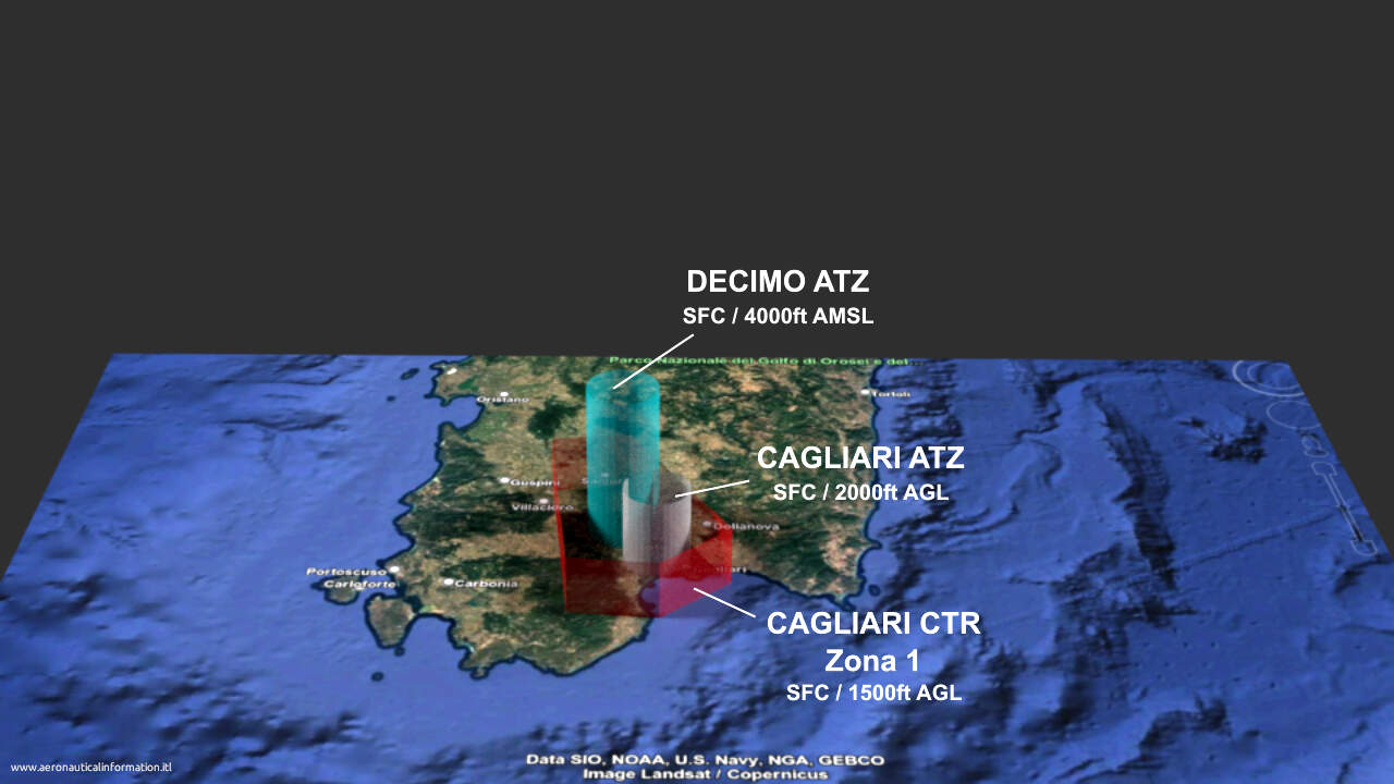
Entro i suoi limiti laterali troviamo le ATZ di Cagliari Elmas e quella dell’aeroporto militare di Decimomannu.
Da notare, però, che entrambe le ATZ possiedono limiti verticali superiori che oltrepassano quelli della zona 1, come vedremo più avanti.
Limiti verticali: SFC / 1500ft AGL
Within its lateral limits we find the ATZ of Cagliari Elmas and that of the military airport of Decimomannu. Note, however, that both ATZs have upper vertical limits that exceed those of zone 1, as we will see later.
Vertical limits: SFC 1500ft AGL
_______
Zona 4
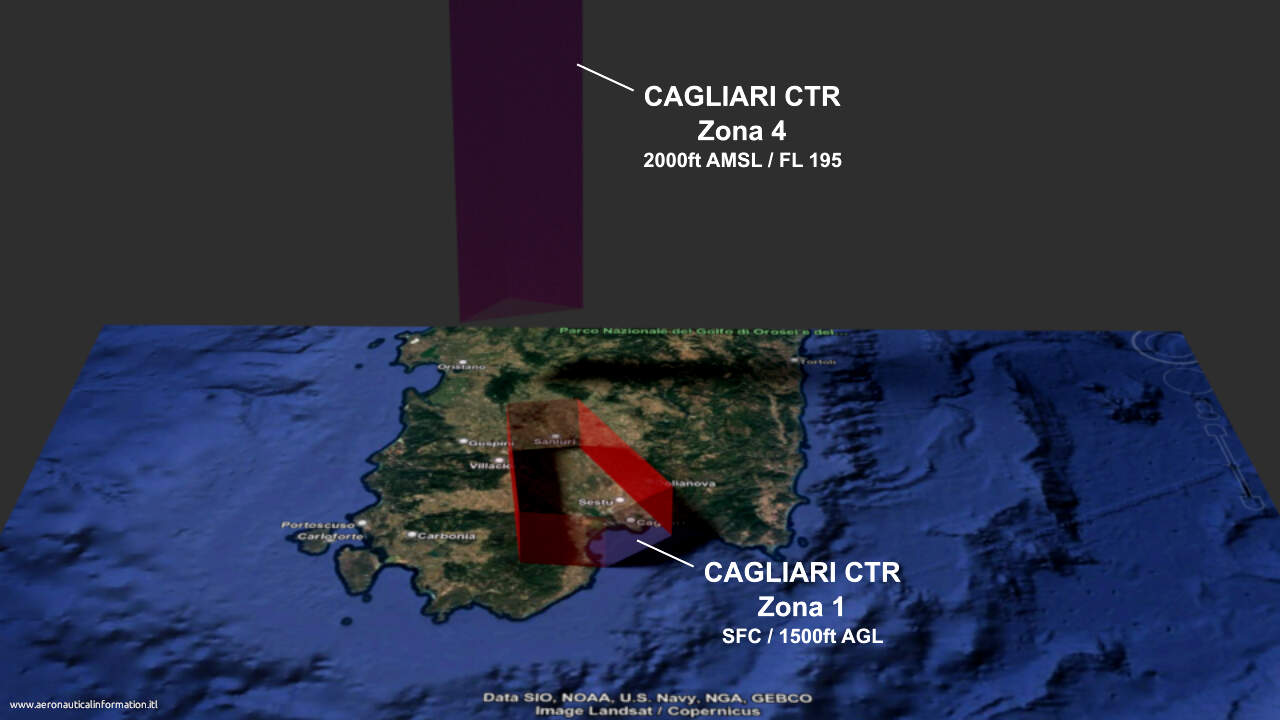
Interferisce parzialmente con lo spazio aereo delle zone regolamentate LI R54/A-B “Oristano” e LI R59/B “Capo Frasca”. Le caratteristiche di queste aree saranno approfondite più avanti.
Limiti verticali: 2000ft AMSL/ FL195
It partially interferes with the airspace of the restricted areas LI R54/A-B “Oristano” and LI R59/B “Capo Frasca.” The characteristics of these areas will be discussed in more detail below.
Vertical limits: 2000ft AMSL / FL195
Nota:
Lo spazio aereo delle rotte ATS è escluso da quello della CTR.
(Informazioni aggiornate alla variante AIRAC A13/25, in vigore dal 25 Dicembre 2025 – variazione dei limiti laterali e verticali)
Remark:
ATS route airspace is excluded from CTR airspace.
(Information updated to AIRAC A13/25, effective December 25, 2025 – change in lateral and vertical limits)
_______
Zona 3
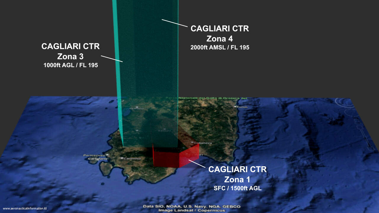
E’ situata a Sud della zona 4.
Interferisce parzialmente con lo spazio aereo delle zone regolamentate LI R54/A-B “Oristano” e LI R59/A-B-C “Capo Frasca”
Inoltre è opportuno segnalare anche la sua interferenza con la zona 1 della CTR e con le ’ATZ di Decimomannu e Cagliari.
Limiti verticali: 1000ft AGL / FL195
It is located to the south of zone 4.
It partially interferes with the airspace of the regulated areas LI R54/A-B “Oristano” and LI R59/A-B-C “Capo Frasca.”
Furthermore, it is worth noting its interference with zone 1 of the CTR and with Decimomannu and Cagliari ATZ.
Vertical limits: 1000ft AGL / FL195
Nota:
Lo spazio aereo delle rotte ATS è escluso da quello della CTR
(Informazioni aggiornate alla variante AIRAC A13/25, in vigore dal 25 Dicembre 2025 – variazione dei limiti laterali e verticali)
Remark:
ATS route airspace is excluded from CTR airspace.
(Information updated to AIRAC A13/25, effective December 25, 2025 – change in lateral and vertical limits)
__________
Zona 2
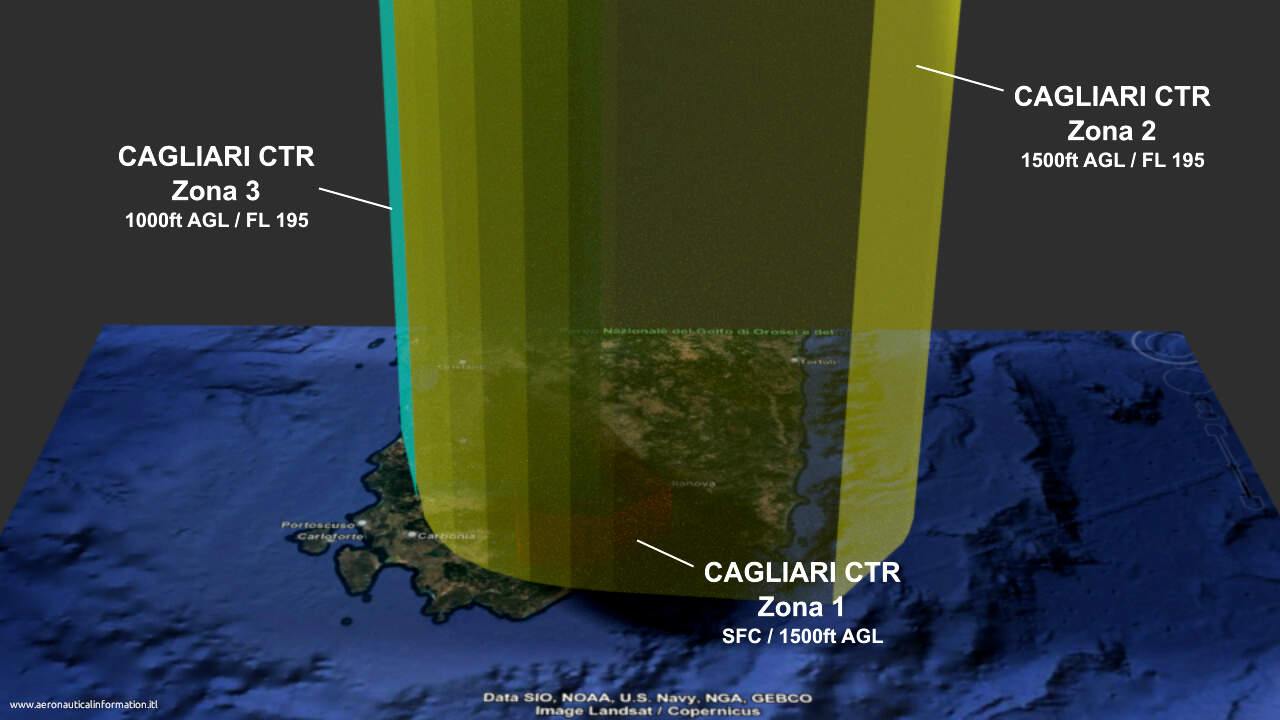
E’ la zona più vasta della CTR e ne copre il settore sud-orientale.
A Sud-Ovest si segnala la sua interferenza con le zone regolamentate LI R54A-B “Oristano” e LI R46/A-B “Capo Teulada”.
Limiti verticali: 1500ft AGL / FL 195
This is the largest area of the CTR and covers its southeastern sector.
In the southwest, it interferes with the restricted areas LI R54A-B “Oristano” and LI R46/A-B “Capo Teulada.”
Vertical limits: 1500ft AGL / FL195
Nota:
Lo spazio aereo delle rotte ATS è escluso da quello della CTR.
(Informazioni aggiornate alla variante AIRAC A13/25, in vigore dal 25 Dicembre 2025 – variazione dei limiti laterali e verticali)
Remarks:
ATS route airspace is excluded from CTR airspace.
(Information updated to AIRAC A13/25, effective December 25, 2025 – change in lateral and vertical limits)

//////
Roma CTA
Evidenzio la presenza della zona 2 della CTA di Roma “Mediterraneo”, tuttavia, ricordo che lo spazio aereo della CTR di Cagliari è escluso da quello della CTA.
I highlight the presence of zone 2 of Roma CTA “Mediterraneo,” however, I would like to point out that the airspace of the Cagliari CTR is excluded from that of the CTA.

_____
Controllo di Avvicinamento / Approach Control Service
Il servizio APP è assicurato H24 dall’Aeronautica Militare sulle frequenze:
APP – Cagliari Approach – 119.275 MHz – H24
APP – Cagliari Approach – 122.950 MHz – utilizzabile a discrezione ATC
APP – Cagliari Radar – 122.950 MHz – Nel settore Ovest il servizio di avvicinamento è fornito con ausilio del radar a discrezione ATC. Inoltre, il servizio viene svolto con l’ausilio del radar a discrezione ATC nei seguenti orari: 2300-0500 (2200-0400)
(Informazioni aggiornate alla variante AIRAC A1/25, in vigore dal 23 Gennaio 2025)
////
Note:
1) La copertura non è assicurata dalla superficie fino a 3000ft nei settori 080°/130° e 185°/300°.
2) Entro la CTR di Cagliari, in deroga a quanto pubblicato nel Regolamento UE 1079/2012, gli operatori di aeromobili possono continuare ad impiegare aeromobili muniti di apparecchiature radio con capacità di canalizzazione a 25 kHz.
The approach control service is provided H24 by the Air Force on following frequencies:
APP – Cagliari Approach – 119.275 MHz – H24
APP – Cagliari Approach – 122.950 MHz – available at ATC discretion
APP – Cagliari Radar – 122.950 MHz – Within West sector Approach control service assured with radar at ATC discretion. In addition, service is provided with the use of radar at ATC discretion during the following times: 2300-0500 (2200-0400)
(Information updated at AIRAC A1/25, in force from January 23 2025)
//////
Remarks:
1) Coverage is not provided from the surface up to 3000ft within the 080°/130° and 185°/300° sectors.
2) Within Cagliari CTR, by way of derogation from what is published in EU Regulation 1079/2012, aircraft operators may continue to use aircraft equipped with radio equipment with 25 kHz channel capacity.
______
ATZ e zone sottoposte a restrizione / ATZ and areas subject to restrictions
In un dettaglio della zona 1 della CTR è possibile apprezzare la conformazione delle ATZ di Decimomannu e Cagliari
In a detail of zone 1 of the CTR it is possible to appreciate the conformation of Decimomannu and Cagliari ATZ.

DECIMOMANNU ATZ
Posta a protezione del traffico dell’aeroporto militare di Decimomannu.
Con il suo limite verticale superiore posto a 4000ft AMSL svetta ben al di sopra della zona 1 della CTR. Dal suo spazio aereo va però escluso quello dell’ATZ di Cagliari.
L’ente ATS responsabile è Decimo Tower, che opera sulle frequenze 122.100 e 140.400 MHz, nei seguenti orari: Lunedì-Giovedì 0630/z-1445/z (0530/z-1345/z) Venerdì 0630/z-1130/z (0530/z-1030/z).
Trattandosi di un aeroporto militare, l’estensione dell’orario di servizio è sempre possibile, se motivata da esigenze operative.
it covers the air traffic of the military airport of Decimomannu.
With its upper vertical limit at 4000ft AMSL is well above CTR zone 1.
The airspace Cagliari ATZ must be excluded from its airspace.
The responsible ATS unit is Decimo Tower, which operates on the frequencies 122.100 and 140.400 MHz, during the following hours and periods: Monday-Thursday 0630/z-1445/z (0530/z-1345/z) Friday 0630/z-1130/z (0530/z-1030/z).
Being a military airport, the extension of the service hours is always possible, if motivated by operational requirements.
////
CAGLIARI ELMAS ATZ
Posta a protezione del traffico dell’aeroporto civile di Cagliari Elmas.
I 2000ft AGL del suo limite verticale superiore superano, seppur di poco, quelli della zona 1 della CTR.
L’ente ATS responsabile è Elmas Tower (ENAV SpA), che opera sulle seguenti frequenze:
120.605 MHz – H24 – spaziatura 8.33 KHz
122.100 MHz – H24 –
125.430 MHz – 0600/z-2000/z (0500/z-1900/z) – spaziatura 8.33 KHz – chiamata radio: Elmas Ground
L’ATIS (Cagliari Arrival and Departure Info) è disponibile H24 sulla frequenza 127.055 MHz (spaziatura 8.33 MHz)
it covers the air traffic of the civil airport of Cagliari Elmas.
Its upper vertical limit (2000ft AGL) exceeds, albeit slightly, those of CTR zone 1.
The responsible ATS unit is Elmas Tower (ENAV SpA), which operates on the following frequencies:
120.605 MHz – H24 – 8.33 KHz spacing
122.100 MHz – H24 –
125.430 MHz – 0600/z-2000/z (0500/z-1900/z) – 8.33 KHz spacing – radio call: Elmas Ground
ATIS (Cagliari Arrival and Departure Info) is available H24 on frequency 127.055 MHz (spacing 8.33 MHz)
////
Zone vietate / Prohibited Areas
Fra le zone dove il traffico aereo è interdetto, si segnalano:
Areas where air traffic is interdicted include:
////
LI P269 UTA
A Ovest dell’ATZ di Cagliari. Sono previste eccezioni per il traffico che segue le procedure strumentali da/per gli aeroporti di Cagliari Elmas e Decimomannu.
Limiti verticali: SFC / 1500ft AGL
West of Cagliari ATZ. Exceptions are made for traffic following instrumental procedures to/from Cagliari Elmas and Decimomannu airports.
Vertical limits: SFC / 1500ft AGL
////
LI P175 Domusnovas
A Ovest dell’ATZ di Decimomannu. Sono previste eccezioni per gli aeromobili di Stato, in emergenza, del servizio antincendi, Protezione Civile, per la salvaguardia della pubblica incolumità.
Ulteriori deroghe devono essere coordinate di volta in volta con RWM Italia S.p.A. Security Aziendale.
Limiti verticali: SFC / 700m AGL
West of Decimomannu ATZ. Exceptions are made for State aircraft, in emergency, fire-fighting service, Civil Protection, for the protection of public safety.
Further exceptions must be coordinated from time to time with RWM Italia S.p.A. Corporate Security.
Vertical limits: SFC / 700m AGL
/////
LI P290 Is Arenas
Ai confini della zona 3 della CTR. Non sono previste eccezioni.
Limiti verticali: SFC / 1500ft AGL
At the boundaries of CTR Zone 3. There are no exceptions for flight ban.
Vertical limits: SFC / 1500ft AGL
////
Altre zone / Other areas
Zona aviolancistica SERDIANA / parachuting area SERDIANA
Situata a Est dell’ATZ di Decimomannu, appena al di fuori dei limiti laterali della zona 1 della CTR. Attiva da mezz’ora prima dell’alba a mezz’ora dopo il tramonto, soggetta a coordinamento con Roma ACC.
Obbligo di transponder per gli aeromobili coinvolti.
Enti ATS responsabili: Cagliari APP e Roma ACC/FIC
Limiti verticali: SFC / FL170
Located east of Decimomannu ATZ, just outside the lateral limits of CTR zone 1. Active from half an hour before sunrise to half an hour after sunset, subject to coordination with Rome ACC.
The transponder is mandatory for aircraft involved.
Responsible ATS bodies: Cagliari APP and Rome ACC/FIC
Vertical limits: SFC / FL170
/////
Zona e corridoio VDS DECIMOPUTZU / ULM area and corridor DECIMOPUTZU
Ad Ovest dell’ATZ di Decimomannu si trovano la zona ed il corridoio per il volo da diporto sportivo Decimoputzu.
Attivi da mezz’ora prima dell’alba a mezzìora dopo il tramonto e soggetti a preventivo coordinamento con Cagliari APP.
I suoi limiti laterali stati modificati con la variante AIRAC A4/24, in vigore dal 18 Aprile 2024.
Limiti verticali: SFC / 500ft AGL
To the west of the Decimomannu ATZ are located the area and the corridor for ultra-light machines Decimoputzu.
Active 30min before sunrise until 30 min after sunset and subject to prior coordination with Cagliari APP.
Its lateral limits have been changed by AIRAC amendment A4/24, effective April 18, 2024. (The images in this post do not yet iclude this change, so I attach an excerpt from the updated AIP VFR chart.)
Vertical limits: SFC / 500ft AGL
/////
Riserva naturale / wildlife nature reserve MOLENTARGIUS / SALINE
Nell’area evidenziata in verde nell’immagine che segue, è vietato il decollo, l’atterraggio ed il sorvolo a bassa quota a tutti gli aeromobili ed ai voli da diporto sportivo, eccetto quando in emergenza o per operazioni di soccorso, spegnimento incendi o di interesse delle Riserve stesse, autorizzati dalla Direzione della Riserva.
Limiti verticali: SFC / 1000ft AGL
In the area highlighted in green in the following image, it is forbidden to take off, land and fly over at low altitude to all aircraft and ultra light machines, except when in emergency or for rescue operations, firefighting or interest of the Reserves, authorized by the Management of the Reserve.
Vertical limits: SFC / 1000ft AGL

//////
Punti di riporto VFR
Nella prossima immagine sono visibili i punti di riporto utilizzati per il traffico VFR all’interno della CTR.
The next image shows the reporting points used for VFR traffic within the CTR.

/////
Zone regolamentate e pericolose / Restricted and Dangerous areas
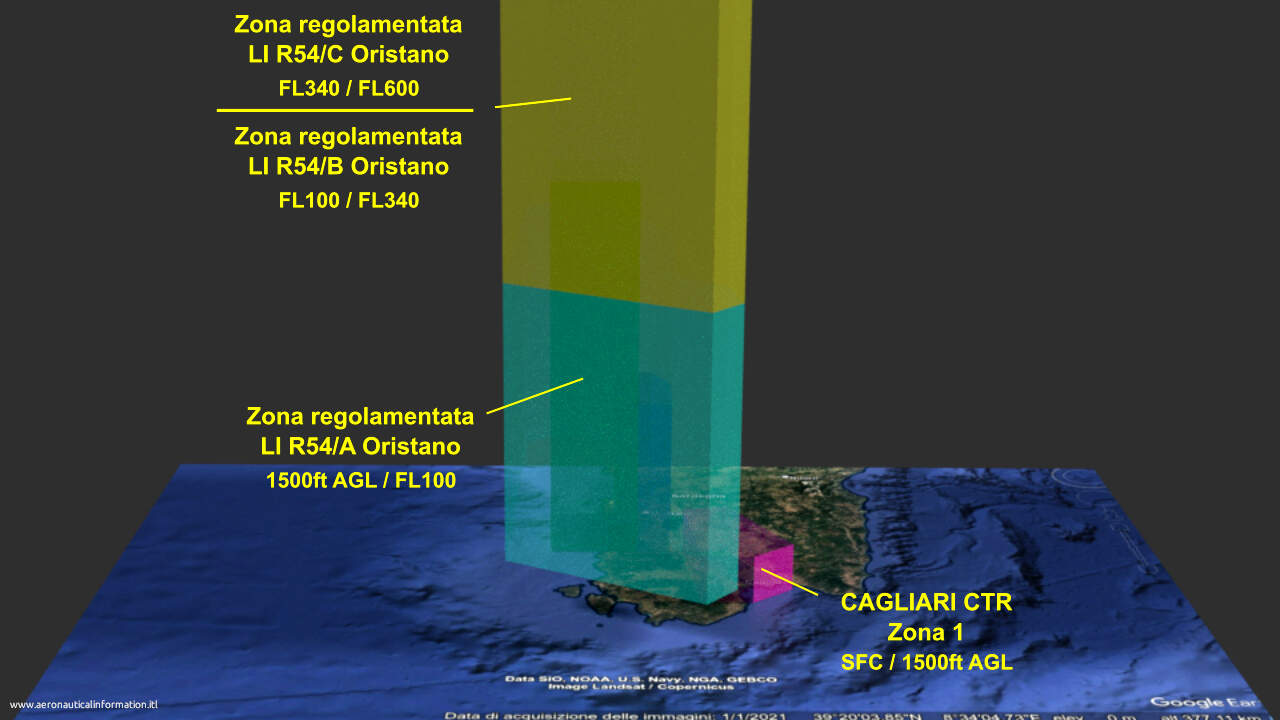
LI R54 Oristano
E’ un’area di dimensioni notevoli, che si estende verso Nord fino ai limiti laterali della Control Area Sardegna.
Importante anche il suo ingombro verticale, visto che il limite superiore giunge a FL 600.
E’ suddivisa nei seguenti di settori sovrapposti:
LI R54/A – Limiti verticali: 1500ft AGL / FL100
LI R54/B – Limiti verticali: FL 100 / FL 340
LI R54/C – Limiti verticali: FL 340 / FL 600 – (AMC manageable)
Vi si svolge intensa attività di aviogetti militari ed allenamento traino manica, dal Lunedì al Venerdì HR 0630-2200 (0530-2100), con l’esclusione dei giorni festivi. Sabato attività possibili previa emissione NOTAM.
L’ente ATS responsabile è Cagliari APP.
Può essere attraversata in accordo alle procedure descritte in AIP ENR 5.1
Nota:
I suoi limiti laterali sono stati sottoposti a revisione con la variante AIRAC A13/25, in vigore dal 25 Dicembre 2025.
It is an area of considerable size, extending northward until the lateral limits of the Sardegna Control Area.
Its vertical extension is also important, since the upper limit reaches FL 600.
It is divided into the following overlapping sectors:
LI R54/A – vertical limits: 1500ft AGL / FL100
LI R54/B – vertical limits: FL 100 / FL 340
LI R54/C – vertical limits: FL 340 / FL 600 – (AMC manageable)
There is an intense activity of military jets and sleeve towing, from Monday to Friday HR 0630-2200 (0530-2100), with the exclusion of holidays. Saturdays activities may took place previous NOTAM issue.
The responsible ATS unit is Cagliari APP.
It can be crossed according to the procedures described in AIP ENR 5.1
Remark:
Its lateral limits have been revised with AIRAC A13/25 amendment, effective from December 25, 2025.
///
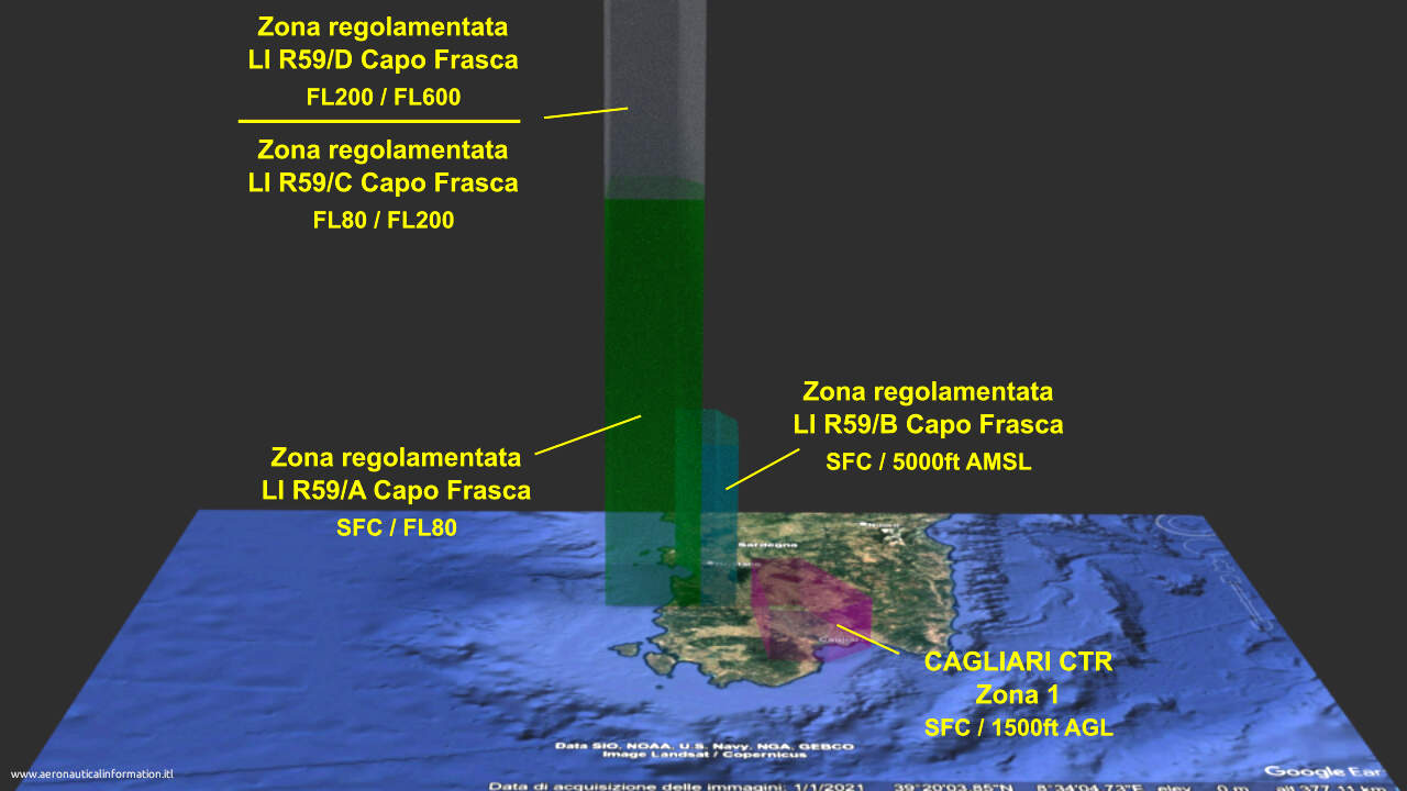
LI R59 Capo Frasca
Risulta completamente contenuta nella zona regolamentata LI R54.
Vi si svolgono esercitazioni di tiro a fuoco aria-terra (settori A,C e D) e intensa attività di aviogetti militari (settore B), dal 1 Settembre al 30 Giugno di ogni anno, come segue: Lunedì-Venerdì 0630/z-2200/z (0530/z-2100/z), festivi esclusi.
Eventuale attività svolta di Sabato viene preannunciata a mezzo NOTAM.
Il traffico aereo è proibito nei periodi di reale occupazione, ma la zona può essere attraversata in accordo alle procedure descritte in AIP ENR 5.1. L’ente ATS responsabile è Cagliari APP.
E’ suddivisa nei seguenti settori:
LI R59/A – situata nella zona centrale della LI R54 – limiti verticali: SFC / FL80
LI R59/B – situata ad Est dei settori A e C, fino ai confini della LI R54 – limiti verticali: SFC / 5000ft AMSL
LI R59/C – sovrasta il settore A – limiti verticali: FL 80 / FL 200
LI R59/D – sovrasta il settore C – limiti verticali: FL 200 / FL 600
Nota:
Le informazioni sono aggiornate alla variante AIRAC A13/25, in vigore dal 25 Dicembre 2025. (aggiunta del settore “D”).
It is completely included in the restricted area LI R54.
Air-to-ground firing exercises (sectors A, C and D) and intense military jet activity (sector B) take place there from September 1 to June 30 of each year, from Monday to Friday 0630/z-2200/z (0530/z-2100/z), excluding holidays.
Any activity carried out on Saturday will be announced by NOTAM.
Air traffic is prohibited during the actual occupation periods, but the zone can be crossed according to the procedures described in AIP ENR 5.1. The responsible ATS unit is Cagliari APP.
It is divided into the following sectors
LI R59/A – located in the central area of LI R54 – vertical limits: SFC / FL80
LI R59/B – located east of sectors A and C, to the boundaries of LI R54 – vertical limits: SFC / 5000ft AMSL
LI R59/C – it overlooks sector A – vertical limits: FL 80 / FL 200
LI R59/D – it overlooks sector C – vertical limits: FL 200 / FL 600
Remark:
Information are updated at AIRAC A13/25, in force from December 25 2025. (Sector “D” added)
LI R46 Capo Teulada
Risulta completamente contenuta nella zona regolamentata LI R54.
Interferisce parzialmente con la parte sud-occidentale della zona 2 della CTR.
E’ suddivisa nei seguenti settori:
LI R46/A – limiti verticali: SFC / FL80
LI R46/B – limiti verticali: FL80 / FL250
(L’area sarà attivata su base tattica con l’Ufficio Operazioni della Base Aerea di Decimomannu, tel.+39 070-9662316, con almeno 48 ore di preavviso)
LI R46/C – limiti verticali: FL 250 / FL 600
Vi si svolgono esercitazioni di tiri a fuoco ed attività militare APR, nei seguenti periodi e orari:
Dal 7 Gennaio al 21 Giugno e dal 20 Settembre al 21 Dicembre
Dalla Domenica alle 2300/z (2200/z) al Sabato alle 1200/z (1100/z).
Nei restanti orari e nei giorni festivi la zona è attiva con un preavviso a mezzo NOTAM.
Quando attiva, il traffico aereo è proibito.
Ente ATS responsabile: Cagliari APP.
Procedure per l’attraversamento: vedi AIP ENR 5.1
Nota:
Le informazioni sono aggiornate alla variante AIRAC A13/25, in vigore dal 25 Dicembre (settorizzazione)
It is completely included in the restricted area LI R54.
It partially interferes with the southwestern portion of CTR Zone 2.
It is divided into the following sectors:
LI R46/A – vertical limits: SFC / FL80
LI R46/B – vertical limits: FL80 / FL250
(The area will be activated on tactical basis with BOC Decimomannu AB with at least 48 hours pre-notice at +39 070-9662316.)
LI R46/C – limiti verticali: FL 250 / FL 600
Firing exercises and military unmanned aircraft activity take place there during the following periods and times:
January 7 to June 21 and September 20 to December 21.
From Sunday at 2300/z (2200/z) to Saturday at 1200/z (1100/z).
In the remaining hours and on holidays the zone is active announced by NOTAM.
When active, air traffic is prohibited.
Responsible ATS unit: Cagliari APP.
Procedure for crossing: see AIP ENR 5.1
Remark:
Information are updated at AIRAC A13/25, in force from December 25 2025. (sectorization)
/////
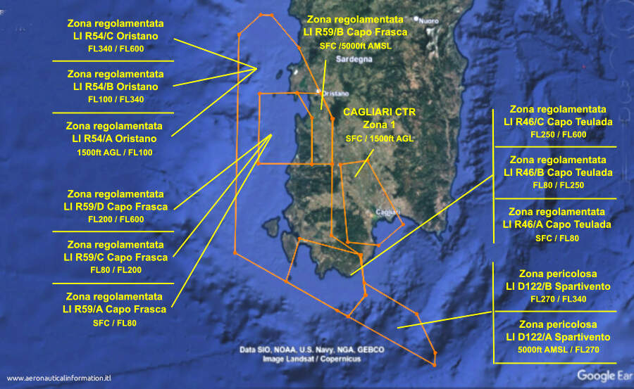
LI D122 Spartivento
Zona pericolosa posta ai margini della CTR, dove si svolge intensa attività di aviogetti militari e di RPAS.
Attiva dal Lunedì al Venerdì HR 0630-2200 (0530-2100). Festivi esclusi. Sabato con preavviso a mezzo NOTAM.
Ente ATS responsabile: ROMA SCCAM in coordinamento con Cagliari APP.
Procedure per l’attraversamento: vedi AIP ENR 5.1
E’ suddivisa nei seguenti due settori sovrapposti:
LI D122/A – limiti verticali: 5000ft AMSL / FL270
LI D122/B – limiti verticali: FL270 / FL340 (AMC manageable) – Durante i periodi di reale attivazione della LI TSA626 la zona non potrà essere
pianificata e attivata
(informazione aggiornata alla variante AIRAC A4/26, in vigore dal 16 Aprile 2026)
Danger area located on the edge of CTR, where heavy military air activity and RPAS activity take place.
Active from Monday to Friday HR 0630-2200 (0530-2100). Holidays excluded. On Saturday activity announced by NOTAM.
Responsible ATS unit: ROMA SCCAM in coordination with Cagliari APP.
It is divided into the following overlapping sectors:
LI D122/A – vertical limits: 5000ft AMSL / FL270
LI D122/B – vertical limits: FL270 / FL340 (AMC manageable) During real activity periods of LI TSA626 the zone cannot be planned and used.(information updated at AIRAC A4/26, in force from April 16, 2026).
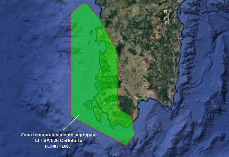
LI TSA 626 Carloforte
I suoi limiti laterali sono stati modificati con la variante AIRAC A10/26, in vigore dal 1 Ottobre 2026.
Interferisce con gli spazi aerei della LI R54/C. della LI R59/D e della LI R46/C. Non interferisce con la zona pericolosa LI D122 “Spartivento”,
Al suo interno si svolge Intensa attività di aviogetti militari, attività aerea supersonica e attività RPAS nei seguenti periodi e orari: Dal Lunedì al Venerdì HR 0630-2200 (0530-2100), festivi esclusi. Sabato con preavviso a mezzo NOTAM.
Ente ATS responsabile: Cagliari APP.
Procedure per l’attraversamento: vedi AIP ENR 5.1
Limiti verticali FL340 / FL600:
______
LI D40 Cagliari
Zona pericolosa completamente contenuta nella FIR di Marsiglia, dove si svolge intensa attività di aviogetti militari e di RPAS (settori A e C) e tiri aria/aria e addestramento al combattimento (settore B).
Attiva dal Lunedì al Venerdì HR 0630-2200 (0530-2100). Festivi esclusi. Sabato con preavviso a mezzo NOTAM. (settori A e C).
Attiva dal Lunedì al Venerdì HJ-/+ 30, festivi esclusi (settore B)
Informazioni sulla reale occupazione possono essere richieste direttamente a Cagliari APP.
Procedure per l’attraversamento dei settori A e C: vedi AIP ENR 5.1
E’ suddivisa nei seguenti tre settori:
LI D40/A – limiti verticali: 1000ft AMSL / FL340
LI D40/B – limiti verticali: 1000ft AMSL / FL195
LI D40/C – limiti verticali: FL 340 / FL600 (sovrapposto al settore A – AMC manageable)
Nota:
Le informazioni sono aggiornate alla variante AIRAC A13/25, in vigore dal 25 Dicembre (modifica dei limiti verticali, orario e tipo di attività, aggiunta del settore C)
Danger area completely contained within Marseille FIR, where take place intense military jet and RPAS activity (sectors A and C) and air-to-air firing and combat training (sector B).
Active from Monday to Friday HR 0630-2200 (0530-2100). Excluding public holidays. Saturdays activity announced by NOTAM. (sectors A and C).
Active Monday to Friday HJ-/+ 30, excluding public holidays (sector B)
Information on actual occupancy can be requested directly from Cagliari APP.
Procedures for crossing sectors A and C: see AIP ENR 5.1
It is divided into the following three sectors:
LI D40/A – vertical limits: 1000ft AMSL / FL340
LI D40/B – vertical limits: 1000ft AMSL / FL195
LI D40/C – vertical limits: FL 340 / FL600 (overlapping with sector A – AMC manageable)
Remark:
information is updated to AIRAC A13/25, in force since December 25 (change in vertical limits, time and type of activity, addition of sector C)

//////
Corridoi traffico aereo operativo / Operative air traffic corridors
Tre corridori per il traffico aereo operativo che interessano la zona 4 della CTR di Cagliari hanno in comune i limiti laterali, ma sono situati a quote diverse.
Essi sono attivi H24, su base tattica, con preventivo coordinamento tra Cagliari APP, Roma SCCAM e Roma ACC.
TC-PERDA LOW – limiti verticali 5000ft AMSL / FL70
TC-PERDA MED – limiti verticali FL 140 / FL160
TC-PERDA HIGH – limiti verticali FL 230 / FL250
Nota 1: La contemporanea attivazione dei corridoi TC-PERDA HIGH e TC-PERDA MED non è consentita
Nota 2: E’ ipotizzabile che i corridoi servano per collegare le zone regolamentate situate a est dell’isola con la LI R54 Oristano.
Three corridors for Operational Air Traffic, affecting zone 4 of Cagliari CTR have common the lateral limits, but they are located at different altitudes.
They are active H24, on tactical basis, prior coordination between Cagliari APP, Rome SCCAM and Rome ACC.
TC-PERDA LOW – vertical limits 5000ft AMSL / FL70
TC-PERDA MED – vertical limits FL 140 / FL160
TC-PERDA HIGH – vertical limits FL 230 / FL250
Note 1: Simultaneous activation of TC-PERDA HIGH and TC-PERDA MED corridors is not allowed.
Note 2: It is conceivable that the corridors are used to connect the restricted areas located east of the island with the LI R54 Oristano.

______
Controllo della velocità
Tutto il traffico IFR in arrivo all’aeroporto di Cagliari, se non diversamente istruito dall’Ente ATC, dovrà osservare rigorosamente la velocità massima come segue:
– 250 kt IAS al di sotto di FL 100;
– 200 kt IAS iniziando la virata per intercettare il LOC;
o
la RDL in caso di avvicinamento finale VOR RWY 32/14;
o
il QDM in caso di avvicinamento finale NDB RWY 32/14;
oppure
ad una distanza di 12 NM dalla soglia pista in caso di corto finale;
– 180 kt IAS al completamento della virata per l’intercettazione, o ad una distanza di 8 NM dalla soglia pista;
– 160 kt IAS ad una distanza di 5 NM dalla soglia pista.
Nota: gli aeromobili militari ed i Voli di Stato non sono tenuti ad osservare le citate prescrizioni.
All ARR IFR traffic if not otherwise instructed by ATC unit shall strictly observe maximum speed as follows:
– 250 kt IAS below FL 100;
– 200 kt IAS starting the turn to intercept the LOC or the RDL in case of VOR RWY 32/14 final approach; or the QDM in case of NDB RWY 32/14 final approach; or at distance of 12 NM from RWY THR in case of straight-in approach;
– 180 kt IAS completing the intercepting turn or at a distance of 8 NM from the RWY THR;
– 160 kt IAS at a distance of 5 NM from RWY THR.
Remark:
Military aircraft and State flights not affected
_______
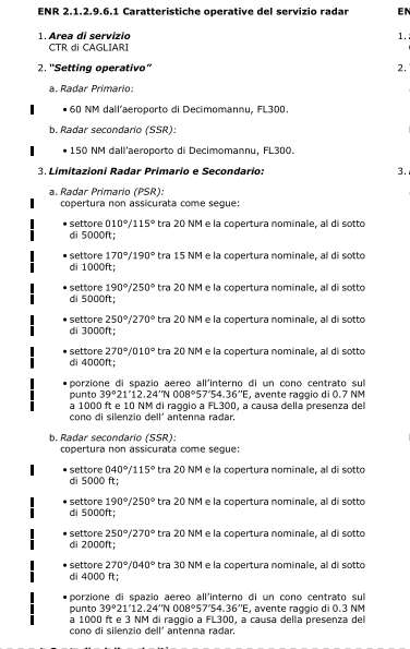
Caratteristiche operative del servizio radar
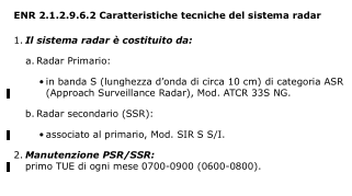
Caratteristiche tecniche del sistema radar
_______
_______
_______

La definizione dello spazio aereo è complicata, macchinosa e di difficile assimilazione
Serve soprattutto a creare confusione ai piloti
Credo che nessun pilota sia in grado di ricordare i contenuti delle regole e dei continui aggiornamenti .
Difficilissima anche la consultazione dei notam soprattutto in volo .
Peccato per tutte queste complicazioni
La creazione di uno spazio aereo ha motivazioni importanti, tuttavia concordo sul fatto che a volte una semplificazione sarebbe auspicabile, sia nei limiti laterali che in quelli verticali.
Per quanto riguarda i NOTAM, rispetto a qualche anno fa ci sono strumenti come le app di navigazione, che rendono la loro fruizione più facile.
Grazie del commento
Fabio Patrassi
Grazie per questo lavoro,
ora è più chiaro per un traffico VDS VFR dove non passare, sempre nel caso si dovesse riuscire a raggiungere la Sardegna del Sud.
Si ha anche un poco l’impressione che più la fanno complicata e meno piloti si azzardano ad infilarsi in certi posti.
Grazie a lei per il commento!
Fabio Patrassi